
Mount Everest Adjusted to Snow Height
 Kathmandu: How tall is Mount Everest? Until now, it depended on whom you asked. China said it was 29,017 feet. Nepal said it was a little taller, at 29,028 feet.
The countries have closed that 11-foot gap and reached an agreement.
The world’s tallest peak this week will get a new, unified official height from the two nations it straddles. After yearslong surveys, China and Nepal will announce the peak’s stature Tuesday, Susheel Dangol, the man in charge of Nepal’s Everest-measurement project, said Sunday.
“The challenge for us was to prove we could do it,” he said.
Measuring Everest has always been a challenge, taxing the latest surveying technology since the 1800s. And it created a disagreement between the mountain’s two homelands.
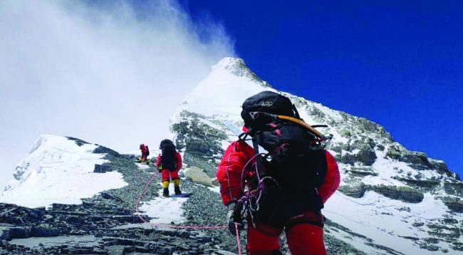
The difference was over rock versus snow.
China’s official height for Chomolungma—its Tibetan name for Everest—was 29,017 feet, from a 2005 survey. China used “rock height,” estimating where the peak lay under the snow.
Nepal has used a “snow height” of 29,028 feet for the peak it calls Sagarmatha, from a 1954 survey India did. That’s where people stand, atop the snow, and the measure is standard practice in most countries.
One of the first official measurements of Everest unveiled globally was in 1855 (29,002 feet). Until a 1975 official measurement by China (29,029 feet), the surveys were by foreigners.
The measured heights of mountains aren’t fixed in stone. New technologies have made it possible to take more-precise estimates, and some mountains shrink: North America’s highest summit, Denali, previously known as Mount McKinley, lost 10 feet when remeasured using satellites in 2015.
The peak’s new measure will come from a first-ever joint announcement by Nepal and China. Everest falls partly in China’s Tibet autonomous region. Chinese teams gauged the distance from gravity and sea level at the Yellow Sea. Nepal’s teams did the same going south to its border with India.
“This is the cat’s whiskers, in terms of doing it right,” said Roger Bilham, professor of geology and Everest-history expert at the University of Colorado, Boulder. “Because it’s a Nepalese-Chinese venture, there were no impediments to access or technology.”
The teams from China and Nepal used everything from old-fashioned trigonometry and surveying equipment such as the theodolite—an optical instrument on a tripod, the kind one sees used during road construction—to satellite positioning and gravity meters.
Measuring the exact height involves climbing to the top and using satellite signals that can locate any point within millimeters. Surveyors must first measure down to sea level, lugging height-measuring and gravity-measuring equipment to the water while taking thousands of measurements.
Measuring Everest anew was a matter of pride for Nepal, which had never itself surveyed its Himalayan peaks before, said Mr. Dangol. Nepal started talking about an Everest survey in 2011. The 2015 earthquake there shook Kathmandu into action as scientists around the world wondered whether the shift in the mountains had changed its height.
Snow height will be Everest’s new official summit, said Nepal’s Mr. Pandey.
“The dispute over rock height and snow height,” he said, “will be a thing of the past.”
— Wall Street Journal